Home | Utility Locating | Subsurface Utility Engineering (SUE)
Comprehensive site investigation identifies horizontal locations of subsurface utilities and structures
National Underground Group’s Subsurface Utility Engineering (SUE) helps protect infrastructure project stakeholders from damaging existing utilities during subsurface installations or rehabilitation by providing three services:
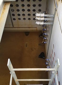
- Subsurface utility designation and mapping services locate the precise location of underground utilities using data accumulated from existing records and maps and comprehensive site investigations to identify the horizontal locations of existing utilities and structures. Once located, we accurately map underground utilities, pinpointing the exact horizontal and vertical coordinates of each structure. The site investigation includes a visual inspection of above-ground utility features such as manholes and valve boxes.
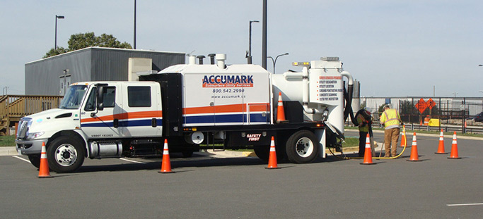
- When utilities need to be uncovered, our subsurface utility location/vacuum excavation service crews uncover subsurface utilities and infrastructure safely and efficiently using hydrovac systems, dry vacuum excavation systems. This approach eliminates mechanical digging, which often puts work crews at risk and can damage existing subsurface infrastructure.
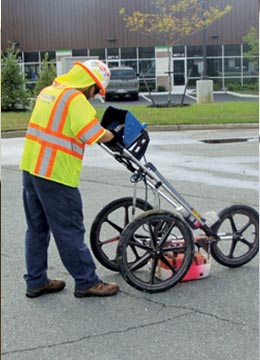
- For projects that require less-invasive investigation, our ground-penetrating radar (GPR) provides underground infrastructure stakeholders with the identification and position of existing subsurface utilities through the use of a nondestructive, geophysical technology that uses radar pulses to image subsurface and buried objects.
National Underground Group’s 811 locating service identifies the precise location of underground utilities. This includes gas, water, sewer, electric and fiber optic lines for municipalities and utility owners and their engineers. In addition, we offer our utility locating services to homeowners and contractors.
Data collected from SUE investigations is correlated with the often less-exact data found in records and maps to help determine the existence and approximate location of below-ground utilities and metallic structures or objects. All mapping and field notes of the location, direction and configuration of utilities are sent to our customers in the form of an AutoCAD or MicroStation file.
Related Services
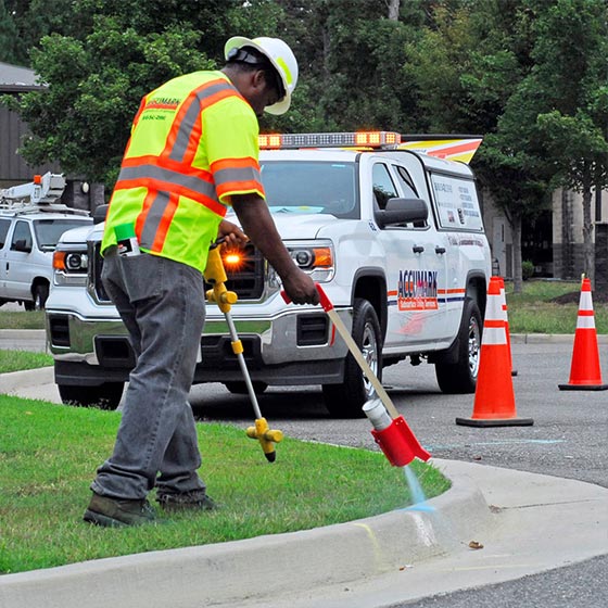
Subsurface Utility Designation and Mapping
Subsurface utility designation and mapping services locate the precise location of underground utilities. This includes providing the disposition of gas, water, sewer, electric and telecommunication lines to municipalities, utility owners and their engineers. Once located, we accurately map underground utilities, pinpointing the exact horizontal and vertical coordinates of each structure. Our maps provide a precise representation of utility positions in proposed work areas.
See Subsurface Utility Designation and Mapping See Subsurface Utility Designation and Mapping See Subsurface Utility Designation and Mapping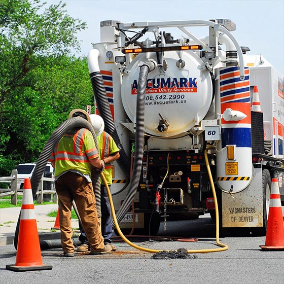
Subsurface Utility Location/Vacuum Excavation
Subsurface utility location/vacuum excavation crews uncover subsurface utilities and infrastructure safely and efficiently using hydrovac systems, dry vacuum excavation systems and combination trucks that control high-pressure water or pressurized air to break up and loosen the soil, while a high-flow vacuum system lifts the soil up and out of the excavation area. This approach eliminates mechanical digging, which often puts work crews at risk and can damage existing subsurface infrastructure.
See Subsurface Utility Location/Vacuum Excavation See Subsurface Utility Location/Vacuum Excavation See Subsurface Utility Location/Vacuum Excavation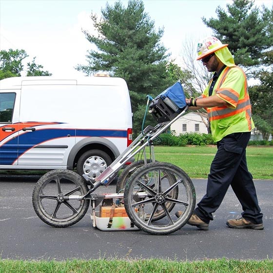
Ground-Penetrating Radar (GPR) & Private Utility Locating
GPR and private utility locating provides civil engineers, general contractors, forensic units and other underground infrastructure stakeholders with the identification and position of existing subsurface utilities. This service employs a nondestructive, geophysical technology that uses radar pulses to image subsurface and buried objects. It can quickly detect utilities, changes in material properties, voids and cracks. GPR can also be used to locate drain fields, underground storage tanks and non-metallic utilities (e.g., A/C, PVC water mains and terracotta pipelines).
See Ground-Penetrating Radar (GPR) & Private Utility Locating See Ground-Penetrating Radar (GPR) & Private Utility Locating See Ground-Penetrating Radar (GPR) & Private Utility Locating
Subsurface Utility Designation and Mapping
Subsurface utility designation and mapping services locate the precise location of underground utilities. This includes providing the disposition of gas, water, sewer, electric and telecommunication lines to municipalities, utility owners and their engineers. Once located, we accurately map underground utilities, pinpointing the exact horizontal and vertical coordinates of each structure. Our maps provide a precise representation of utility positions in proposed work areas.
See Subsurface Utility Designation and Mapping See Subsurface Utility Designation and Mapping See Subsurface Utility Designation and Mapping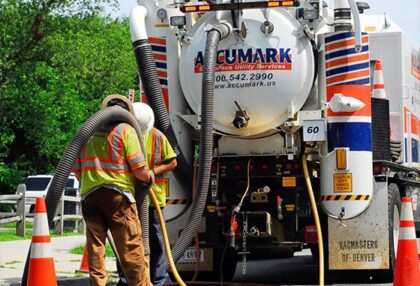
Subsurface Utility Location/Vacuum Excavation
Subsurface utility location/vacuum excavation crews uncover subsurface utilities and infrastructure safely and efficiently using hydrovac systems, dry vacuum excavation systems and combination trucks that control high-pressure water or pressurized air to break up and loosen the soil, while a high-flow vacuum system lifts the soil up and out of the excavation area. This approach eliminates mechanical digging, which often puts work crews at risk and can damage existing subsurface infrastructure.
See Subsurface Utility Location/Vacuum Excavation See Subsurface Utility Location/Vacuum Excavation See Subsurface Utility Location/Vacuum Excavation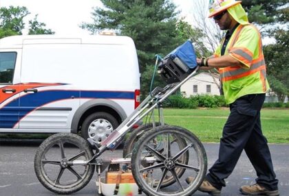
Ground-Penetrating Radar (GPR) & Private Utility Locating
GPR and private utility locating provides civil engineers, general contractors, forensic units and other underground infrastructure stakeholders with the identification and position of existing subsurface utilities. This service employs a nondestructive, geophysical technology that uses radar pulses to image subsurface and buried objects. It can quickly detect utilities, changes in material properties, voids and cracks. GPR can also be used to locate drain fields, underground storage tanks and non-metallic utilities (e.g., A/C, PVC water mains and terracotta pipelines).
See Ground-Penetrating Radar (GPR) & Private Utility Locating See Ground-Penetrating Radar (GPR) & Private Utility Locating See Ground-Penetrating Radar (GPR) & Private Utility Locating