Home | Technology
Robotic- and monopod-mounted cameras collect comprehensive visual inspection data of subsurface-pipe infrastructure
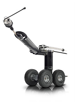
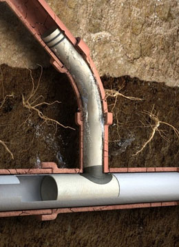
National Underground Group’s visual inspection technologies provide comprehensive views of mainlines, lateral pipes and manholes through closed-circuit television (CCTV) images. The robotic cameras we employ are capable of capturing three different views: a 360° perspective, an unfolded view, and a geometric view. Our visual inspection systems can also be equipped with a 3D pipeline and lateral mapping sensor. Mobility is provided by self-steering robotic crawlers, all-terrain crawlers and track-mounted systems.
Features and capabilities of our robotic visual inspection systems:
- Launches with or against flow
- Inspects mainlines and laterals in single run
- Traverses main lines up to 1,000 feet while capable of launch into laterals
- Features self-leveling lateral camera with sonde
- Traverses 45°- and 90°-degree laterals
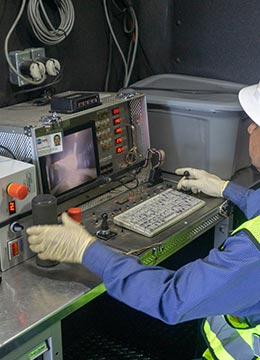
National Underground Group can also provide a monopod camera system for manhole inspections. The pole-mounted system extends up to 30 feet and enables a single operator to collect a sphere of 360° video data during a manhole inspection. And, the data can be offloaded to remote analysts, eliminating time-consuming analysis by operators onsite. This can substantially lower manhole inspection costs by increasing the number of manhole inspections per hour/day.
QC team data management ensures accurate guidance for infrastructure maintenance operations
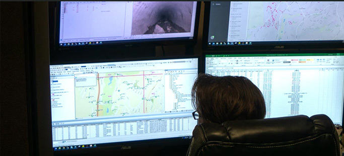
National Underground Group GIS pipeline mapping services provide quality data management that utilizes cloud technologies to link inspection data (including videos and GPS observations) to GIS based mapping systems resulting in a comprehensive, date stamped library vetted by a highly experienced quality control team. Successful data management answers the question of how and when and allowing future generations to access quality data.
Accurate locations of connections, observations, defects and pipe ratings can be integrated into a pipeline GIS database during inspection for delivery in the form of shape files or geo-databases. GIS integration provides certified National Association of Sewer Service Companies (NASSCO) inspection data and cross bore information, which can be efficiently transferred to the Pipeline Assessment and Certification Program (PACP) exchange database.
After inspection, high-definition scans and conventional CCTV recorded observations are collated and sent directly to pipeline mapping software. Data can include pipe slopes, invert elevations and any other specified information required for mapping, potentially saving thousands of hours of work required to search for and collate such information. With more efficient access to the accurate locations of subsurface-pipe infrastructure, utilities, engineers and municipalities are better able to coordinate their underground installation and maintenance projects.
Provides remote access to comprehensive subsurface-pipe infrastructure data and visualization 24/7
National Underground Group offers a user-friendly, cloud-based software data collection and visualization program that collates location intelligence data to create precise maps that can be accessed and shared remotely though an online customer portal, 24/7. Beyond full visualization of pipe infrastructure, it includes detailed records of when inspections were made, the location of repairs, junctions and any history of system failures. This enables accurate-risk assessments and inspection-results analysis to avoid redundant work and make more effective plans for updates and expansions.
Specialized data collection and visualization program benefits:
- User-friendly, cloud-based software
- GIS data base available through an online customer portal, 24/7
- Pipeline assessments using advanced camera and video technology
- Data deliverables guard safety, especially for gas pipeline companies
- Location intelligence used to create precise, sharable maps
- Accurately tracks multiple projects throughout service areas
AI ensures more efficient and effective development of subsurface-pipe maintenance and rehabilitation programs
Condition reports of crucial underground sewer infrastructure are often used to determine how maintenance and rehabilitation programs should be developed, but traditional inspection processes are slow, expensive and inconsistent. National Underground Group uses Artificial Intelligence-based (AI) computer vision tools for automatic identification of conditions in sewer inspection videos.
These AI tools and methods, also known as Automated Defect Recognition (ADR), have proven to be effective in reducing field inspection costs, accelerating workflows for data collection and analysis, and, importantly, contributing to an elevation in the quality, accuracy and consistency of condition assessment data. This enables customers to make better decisions faster, lower backlogs, and use their time and equipment more effectively.
AI also makes it possible to employ customizable analytic tools that express key metrics: likelihood of failure (LoF) and consequence of failure (CoF). Such analytic tools enable asset managers to conduct risk assessments and monitor data inputs from sewer condition assessments to ensure accuracy and consistency.